


Well done on the vid chris, but i thought you would have included something on the huts on the marsh?
Results 11 to 20 of 20
-
08-05-2011, 09:30 AM #11
 UF Senior Member
- Join Date
- Oct 2010
- Posts
- 170
- Thanks
- 8
- Thanked 29 Times in 29 Posts
 Re: Brancaster Coastal Defence Battery
Just cos I lick electrical outlets it doesnt mean I'm stupid.......................I just like the tingle!
Re: Brancaster Coastal Defence Battery
Just cos I lick electrical outlets it doesnt mean I'm stupid.......................I just like the tingle!
forgive us our trespasses
-
08-05-2011, 09:46 AM #12
The Busman
- Join Date
- Aug 2010
- Location
- North Norfolk
- Posts
- 74
- Thanks
- 5
- Thanked 12 Times in 9 Posts
Re: Brancaster Coastal Defence Battery
nah Sebley- thats to do with Titchwell, I believe...
SG is on the case on that one...
-
08-05-2011, 10:20 AM #13
Сталкер
- Join Date
- Feb 2011
- Location
- West Norfolk
- Posts
- 246
- Thanks
- 24
- Thanked 70 Times in 56 Posts
Re: Brancaster Coastal Defence Battery
I'll watch your video this evening Chris..
Shad's, it's all getting very complicated and the area from Holme Dunes to Brancaster CDB is showing a variety of military uses from the mid-1920's to the mid-1950's including air gunnery ranges, air bombing ranges, a non-standard moving target range, tank/artillery range(s), mud crossing trials, beach cratering trials, special purpose vehicle development trials. The huts on the marsh fit in here somewhere, but the current state of research is that every answer is generating two more questions.
-
08-05-2011, 08:20 PM #14
UF Senior Member
- Join Date
- Oct 2010
- Posts
- 170
- Thanks
- 8
- Thanked 29 Times in 29 Posts
Re: Brancaster Coastal Defence Battery
thank you for clearing that up SG. does sound like its a little on the complicated side, ill leave it to the master historian!
Just cos I lick electrical outlets it doesnt mean I'm stupid.......................I just like the tingle!
forgive us our trespasses
-
08-05-2011, 09:12 PM #15
Сталкер
- Join Date
- Feb 2011
- Location
- West Norfolk
- Posts
- 246
- Thanks
- 24
- Thanked 70 Times in 56 Posts
Re: Brancaster Coastal Defence Battery
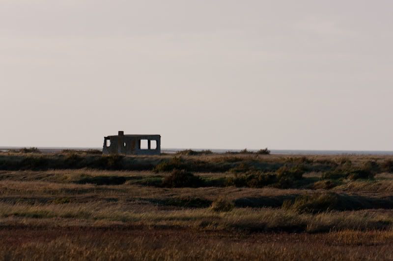
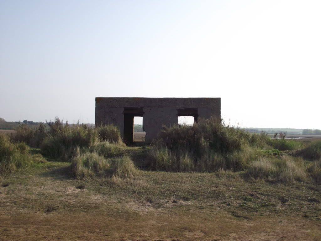
Hah! I'm just getting more confused the more information I get. I've had some very good plans provided by someone on AIx that detail the post-WW2 air-to-ground bombery/gunnery range to the immediate west of the current RSPB reserve (the old tank gunnery range) at Titchwell. Some of the quadrant shelters may correspond to some of the huts on the marshes, except that the huts are clearly visible on the 1946 aerial photographs before the post-war range was planned.
The new (to me) range to the west of Titchwell..
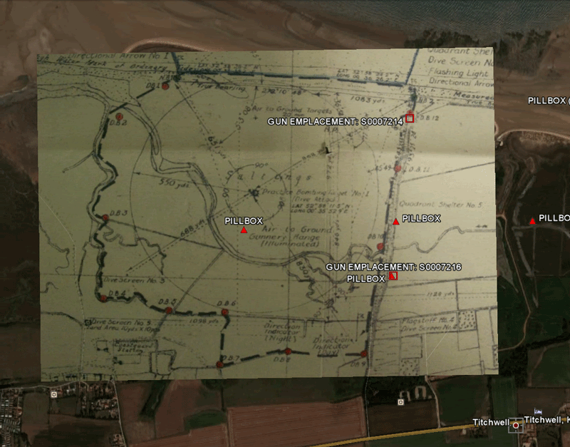
The overlay isn't perfect yet, I'm transferring the lat/long points onto GE and then I'll re-jig the overlay to get it to aligned more accurately.
This is the "pillbox" in the centre of the plan..
The gun emplacements aren't absolutely certain either as some of them are the winch houses for the moving target on the Titchwell AFV range, and some of the other "pillbox" structures are probably range shelters for Titchwell.
NHER and DOB aren't helping, as the original survey was an interpretration of the aerial photographs and NHER quotes DOB and describes all the structures (except those at Holme Dune) as "a World War Two pillbox is visible on aerial photographs taken in 1945" or something similar. Unfortunately, even a quick look across the marsh at several of these makes it obvious that they're not pillboxes.. unless Brancaster had a unique design of thin-walled pillbox with picture windows, fireplace and chimney. If you have any photographs of the structures east of Titchwell and west of Brancaster (i.e. the two remaining ones between the golf club and the RSPB reserve), I'd really appreciate it if you can share them. I've not yet headed out to check these in person yet.
It's possible that there's another range I've not identified between the golf club and Titchwell reserve, or it could be that these were built as refuge/observation shelters for the tracked vehicle trials or the cratering experiments at Brancaster.
I'm trying to keep track of all the reports on this area, as they're feeding in to the larger picture.
-
10-05-2011, 06:57 PM #16
UF Senior Member
- Join Date
- Oct 2010
- Posts
- 170
- Thanks
- 8
- Thanked 29 Times in 29 Posts
Re: Brancaster Coastal Defence Battery
1
2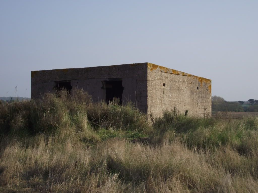
3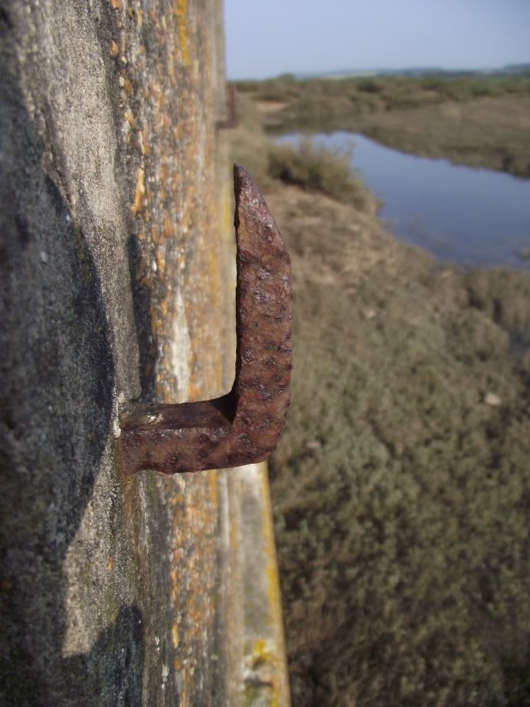 Just cos I lick electrical outlets it doesnt mean I'm stupid.......................I just like the tingle!
forgive us our trespasses
-
10-05-2011, 07:04 PM #17
Сталкер
- Join Date
- Feb 2011
- Location
- West Norfolk
- Posts
- 246
- Thanks
- 24
- Thanked 70 Times in 56 Posts
Re: Brancaster Coastal Defence Battery
I'm pretty sure that's not a pillbox Shad's, but it's also different from the ones on the other side of Titchwell.. interesting hooks, could be for camouflage netting, but a little low (I'd expect netting to be strung from the roof). And a sloping roof? Did you see how many rooms there were inside?
-
10-05-2011, 07:38 PM #18
The Busman
- Join Date
- Aug 2010
- Location
- North Norfolk
- Posts
- 74
- Thanks
- 5
- Thanked 12 Times in 9 Posts
Re: Brancaster Coastal Defence Battery
Just 2 rooms, SG- the building is basically divided in half with a linking doorway in the wall
-
10-05-2011, 08:04 PM #19
UF Senior Member
- Join Date
- Oct 2010
- Posts
- 170
- Thanks
- 8
- Thanked 29 Times in 29 Posts
Re: Brancaster Coastal Defence Battery
the hooks were at the bottom of the windows (land side) i think there were 2 to a window - boards maybe?
Just cos I lick electrical outlets it doesnt mean I'm stupid.......................I just like the tingle!
forgive us our trespasses
-
10-05-2011, 09:45 PM #20
Сталкер
- Join Date
- Feb 2011
- Location
- West Norfolk
- Posts
- 246
- Thanks
- 24
- Thanked 70 Times in 56 Posts
Re: Brancaster Coastal Defence Battery
Ahh.. that makes a bit more sense, I was trying to relate the hooks to the sides of the building that are visible.


Similar Threads
-
Torry Coastal Battery, 03/2010
By ZombieSazza in forum Military sitesReplies: 8Last Post: 03-05-2013, 08:36 AM -
Brancaster Tunnels
By Deepsky in forum Military sitesReplies: 20Last Post: 03-04-2011, 12:11 PM -
Innes Links Emergency Coastal Battery
By wurzel in forum Older Reports ArchiveReplies: 3Last Post: 22-11-2009, 11:08 AM -
Pett Emergency Coast Defence Battery
By acen2006 in forum Older Reports ArchiveReplies: 1Last Post: 16-09-2009, 09:09 AM -
Archived: Brancaster ROC Post - (Norfolk Group) - April 09
By KingElvis in forum NorfolkReplies: 0Last Post: 16-04-2009, 07:42 PM
